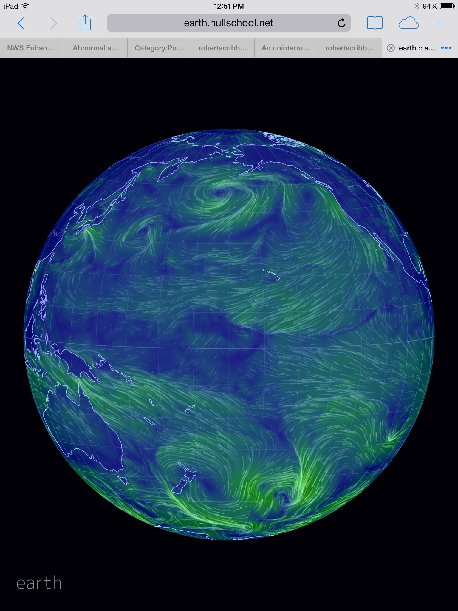
(Pacific Ocean wind pattern as of 1 PM EST, June 4. The brighter the green, the higher the intensity, the deeper the blue, the weaker the winds. Direction of flow indicated by tapering lines. Note the large dead zone in the Pacific equatorial wind belt. Image source:
Earth Nullschool. Data source:
NOAA,
GFS,
MMAB,
EMC,
NCEP,
OSCAR,
UCAR.)
Draw
a line due south of Kauai to the equator and there you will find a
cyclone hovering just to its north.
Cyclones
here usually have their wind fields dilated by the ongoing pressure
of the east-to-west trade winds. As such, typical circular wind flow
around a normal cyclone near the Pacific equator is distorted,
turning instead into a kind of wind hump where the trades slow at the
base and speed up at the top. West winds generally never completely
wrap around these small storms.
But
our cyclone is a bit unusual. For not only is it featuring a west
wind flow of about 10 mph over about a 500 mile stretch of water, it
also pushes ahead of it a trade wind killing frontal boundary. A
sinking and rolling in the atmosphere that is acting like a kind of
wall to the trades — keeping them from further progress.
The
storm is the tip of a spear aimed at the heart of the trades and
around it they bisect, shifting above the 10 degree North Latitude
line in the north and below the 10 degree South Latitude line in the
south. This wide gap features only weak and confused airflows.
North-to-south they meander with the occasional weak east wind and
numerous anomalous west winds filling in this rift. A broad, nearly
1,000 mile wide hole, that continues on west past the Solomons, past
New Guinea, and on all the way to the Philippines.
To
the East, a second 2,000 mile stretch of west winds running from
south of California and on to the South American coast crowds out the
trades. Together with the great wind gap to the west, these two
patterns combine to cut off the trades from much of the Equator. What
is left is only about 3,000 miles of uninterrupted flow. A mere 30%
of the pattern’s typical range.
The
El Nino Feedback
So
why all the drama? What’s so important about trade winds anyway?
Well, from the point of view of the developing monster weather event
that is El Nino — almost everything.
For
El Nino to grow and progress, in essence, for the massive pile of
warm water that has accumulated in the Western Pacific to keep
flowing east, the trade winds have to fail. They do this either
through strong west wind events that open the gates to warm surface
water flow eastward. Or they do it through a kind of trade wind
collapse.
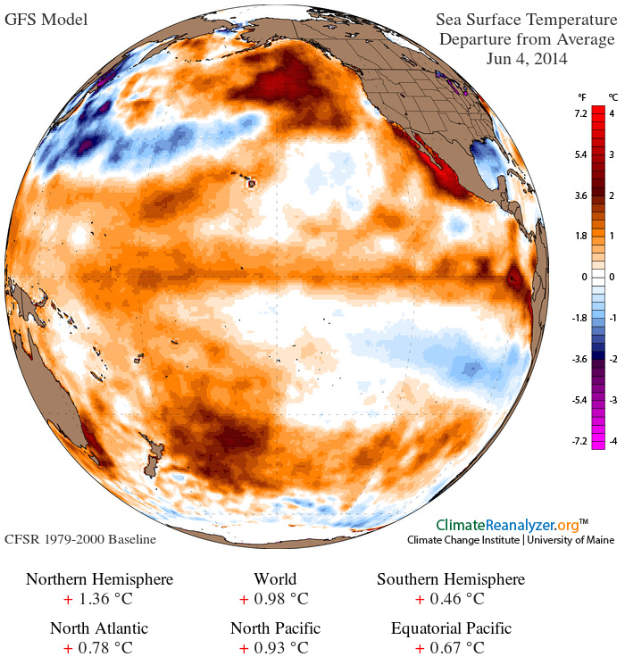
(Equatorial Pacific Ocean temperatures warmed to near +0.70 this week as global sea surface temperatures remained in an extraordinarily hot range near +1 C above the already hotter than normal 1979 to 2000 average. A rising El Nino combined with global warming pushed April of 2014 to its hottest temperatures on record and likely had the same effect on May. Any further intensification of El Nino is likely to push this dire trend into even more extreme territory. Image source:
University of Maine. Data Source:
GFS.)
It
is this kind of event that climate experts call an El Nino feedback —
an atmospheric condition that sets in place the features that allow
Pacific Ocean surface warming to intensify along a strengthening El
Nino path. As of yesterday, and continuing on through today, that
feedback is readily visible in what appears to be a mass trade wind
die-off. A great hole punched through the heart of equatorial air
flow.
Such
a condition, according to past weather observations, should give what
is already a strengthening El Nino a boost. So it appears the
potential for a monster El Nino today again ramped higher.
Links:


No comments:
Post a Comment
Note: only a member of this blog may post a comment.