

Monsoon
At Dead Halt: Chances For Summer El Nino Jump to 70% as India
Swelters
5
June, 2014
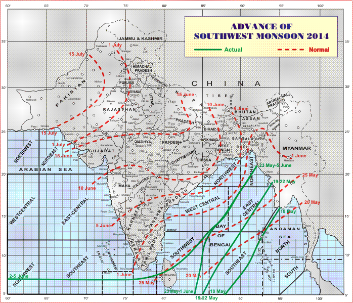
Current advance of the Indian Monsoon indicated by the green line vs typical historic advance indicated by the dashed red line. Image source: India Meteorological Department.
The
Indian Monsoon arrived in Sri Lanka on June 2nd, 8 days late, with
extreme force. Dumping excessive rainfall even for a typically
powerful event, it forced 2,500 to flee and resulted in the loss of
22 souls. There it stalled, battening into a Bay of Bengal moisture
flow that hasn’t budged since May 23rd.
*
* * *
By
today, June 5th, powerful storms should be dumping rain over a wide
swath including the entire southern tip of India, almost all of the
waters between Myanmar and the Tamil Nadu and Andhra Pradesh coasts,
and over most of Bangladesh. But in the satellite shot only scattered
storms are visible where powerful, wall-to-wall squalls should now
cover an impressive swath.
By
this time last year, more than a third of India was obscured by
cloud. Today, the skies of this nation of 1.25 billion people are
ominously clear. The steely-gray aerial tint of coal ash smog is the
most impressive feature in an otherwise open expanse from the
northwest deserts to the southeast coast. A massive zone showing only
sparse hint or hope of rain.
Even
Sri Lanka seems mostly cloud-free. The monsoon and, more importantly,
the crop-essential rains it brings are walled out, pushed into the
margins by El Nino and some of the hottest global temperatures on
record.
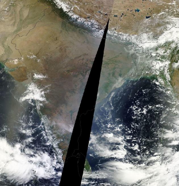
Blazingly clear skies laced with ominous coal ash over India during a time when monsoonal storms usually advance. Image source: LANCE-MODIS.
Forecasts
indicate that some of the long-delayed rain could arrive to the coast
by tomorrow through Sunday. Sparse comfort to sweltering interior
sections that may not now see the cooling monsoon until after July
1st.
Unrelenting
Heat Risks Late Switch to Violent Storms
In
the north, the heat and drought just builds and builds. Jaipur
recorded its highest temperature in 33 years on Thursday at a
scorching 46.3 degrees Celsius (115.3 F). Meanwhile, New Delhi hit a
new record high for the day of 45 C (113 F). Forecasts for New Delhi
on Saturday and Sunday show the potential for even more extreme heat
with temperatures projected to climb to 116 F. Over the coming ten
days, the coolest is expected to be Friday of next week at 109 F.
The
continued delay of monsoonal rain combines with record heat
throughout northern and western sections of India to enhance risks of
drought and loss to crops. Heatwave conditions have already reduced
Lychee fruit crop yields by 40%. But an extended stalling of the
monsoon and ongoing heat could result in increased damage.
Atmospheric
thickening that comes with such extreme heat can also spur intense
rain and hail events causing another kind of damage to crops. So a
flash switch from heat to heavy storms like those seen earlier this
week in Sri Lanka may not be so much of a boon as a terrible jolt to
affected lands.
Moderate
to Strong El Nino Ever More Likely
This
year’s monsoonal delay and related extreme weather were likely
amplified by a combination of record atmospheric heat due to
human-caused greenhouse gas forcing and a growing and strengthening
El Nino. In April, global atmospheric temperatures hit new record
highs of +.91 C above 1880s values even as El Nino rapidly gained
ground in the Pacific through May.
Multivariate
ESNO Index values catapulted to +0.93 in May hitting the seventh
highest values on record for the month and pushing the current El
Nino into Moderate-Strong range for this time of year. During
previous years, similar high values resulted in strong El Ninos on 3
of 5 occasions in the climate record. So historical indicators point
toward a 60% chance of a strong event emerging by later this year.
From
to NOAA’s
El Nino Discussion Page:
The
long anticipated breakthrough to El Niño conditions in 2014 is
clearly under way, leading to the next question of how big it will
get. Of the 10 nearest-ranked April-May values, five had clearly come
up to this level over the previous three months. Among those five,
four continued at El Niño levels through the rest of the year, while
one (1993) dropped back to borderline neutral conditions by the end
of the year. One (2002) ended up as a weak-to-moderate event, while
the other three (1957, 1987, and 1997) are classified as strong El
Niño events in the MEI sense. In other words, the simple-minded odds
for El Niño remain at or above 80% through the remainder of 2014,
and are consistent with previous discussions on this website. The
odds for a strong El Niño are perhaps slightly higher than before,
somewhere around 60%.
Meanwhile,
the official NOAA forecast is more cautious, with model
interpretations pointing to a higher likelihood for a moderate El
Nino during 2014.
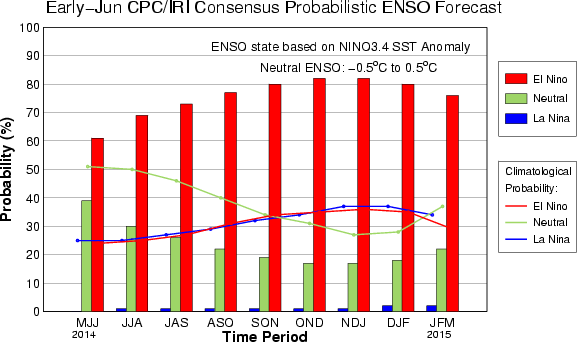
El Nino probability graph. Image source: CPC.
Overall,
chances for evolution to full-blown El Nino rose significantly with
today’s forecast now showing a 70% chance for El Nino development
by this summer and nearly an 85% chance for El Nino development by
Fall-Winter.
Regardless
of El Nino strength, such an event is likely to have broad-ranging
global impacts in the context of human-caused warming.
India’s
Heightening El Nino + Climate Change Threat to Crops
For
India, history shows numerous cases of severe monsoonal disruption
during strong, moderate, and, recently, even weak El Nino events. In
addition, record high atmospheric temperatures enhance extreme
drought and flood potentials by amping up the hydrological cycle and
thus increasing the rate of both evaporation and precipitation.
Storms, where they do occur tend to be both tall and abnormally
powerful under current human-warming related stresses even as
droughts tend to develop with higher velocity and to persist for
longer periods.
It
is possible, due to both changes to the hydrological cycle and to
atmospheric circulation, that the Indian monsoon has become even more
sensitive to the El Nino pattern under current human-caused warming.
This year’s monsoonal delay with El Nino just emerging shows an
almost instant response to the forcing coming from increased
temperatures in the Equatorial Pacific. As such, conditions of
heightening threat for crop damage throughout a land where 1.25
billion people rely on the annual rains is a critical issue.
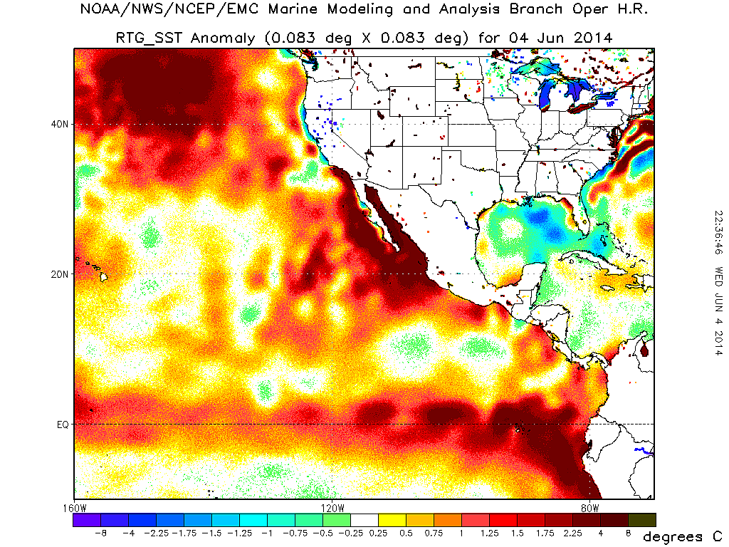
(Extraordinary
sea surface temperature anomalies in the Northeast Pacific including
numerous pools of +2.25 to +4 C or higher departures are indicative
of both a strengthening El Nino pattern and a general warming of
Ocean surface waters through human greenhouse gas heat forcing. Image
source: NOAA
Environmental Modeling.)
Overall,
the forecast remains for continued monsoonal delay and disruption,
continued heatwaves and a likelihood for extreme rainfall and storms
in the regions where the monsoon finally arrives. With El Nino
conditions in place over the Pacific now, with atmospheric
temperatures rising into record range, and with an official El Nino
status likely to be declared by summer, this forecast is lent yet
more certainty and urgency.
Links:
(Hat
Tip to Timothy Chase)
No comments:
Post a Comment
Note: only a member of this blog may post a comment.