

Jet Stream Tattered By Climate Change Brings New Bout of Worst Storms On Record For North-Central US
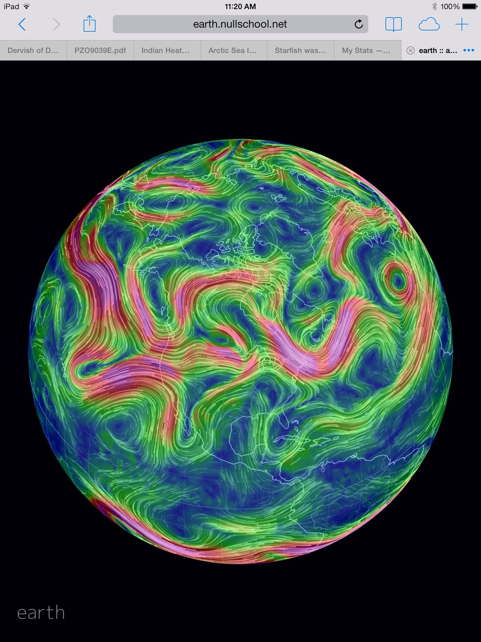
(Mangled Jet Stream on June 20th, 2014 together with cut-off upper air low threatens record-shattering storms and flood events across a multi-state region from the Dakotas to Minnesota to Iowa and Nebraska over the coming days. Image source: Earth Nullschool. Data source: NOAA.)
20
June, 2014
If
you wanted an example of a Jet Stream mangled by human-caused climate
change, you couldn’t find a better one than today’s tangle of
upper level winds swirling over North America.
It’s
a chaotic maelstrom of split flows, colliding storm tracks, blocking
highs, and cut-off upper air lows. A barrel of snakes pattern that’s
become ever-more-common since Arctic sea ice plummeted to staggering
volume lows of nearly 80 percent less than 1979 levels at end summer
of 2012. A loss that opened wide the gates for warm air to flood
northward and confuse the hot-cold dividing line that drives this key
weather governor.
Over
the past week, we’ve seen what amounts to a mess of storms mostly
locked in place. A Pacific Ocean flow squeezed between a blocking
high off California and an upper level low south of Alaska drew a
train of moisture trailing all the way across the Pacific into a
hungry cut-off low that had stalled along the border between Canada
and the US. Drifting slowly east to west, west to east, the low
gorged on the synoptic moisture feed, dumping record rainfall after
record rainfall over the Dakotas, Minnesota, Nebraska and Iowa.
100
Year Records Shattered
By
the 16th of June, with just slightly more than half the month passed,
Sioux Falls South Dakota had crushed its all-time record rainfall for
any month by more than 2.5 inches.The
previous record of 9.42 inches set in 1898 catapulting to a
staggering 13.04 inches by early this week. And with the storm
track writhing overhead the rains for the region just kept coming. By
yesterday, the twin cities region in Minnesota had rocketed to its
second wettest June on record amidst massive rainfall-driven
landslides and region-wide preparations for Mississippi River
flooding. At 10.33 inches measured rainfall so far, with storms still
popping overhead, and with 11 days still remaining in the month, it
appears the area may well be set to shatter the previous rainfall
record of 11.67 inches set back in 1874.
(Record flooding along the Big Sioux River in Iowa and South Dakota as witnessed yesterday by Storm Chasers.)
All
the massive rainfall has built up quite a pulse of flood water that
is now moving down major river systems and threatens record flooding
events throughout a multi-state region from the Dakotas to Minnesota
to Iowa to Nebraska. Residents are being called to aid in sand
bagging and other flood mitigation operations as rivers keep rising
through numerous regions. According
to a report today in the Christian Science Monitor:
“In
Iowa, South Dakota, and Nebraska, officials are asking volunteers to
build sandbag barriers and other fortifications in advance of the
brunt of the storm – but politicians and emergency workers are
conceding that their efforts, in some areas, may not be enough.
In
South Dakota, workers have begun turning a major Interstate exchange
bridge into a temporary levee. While officials there say that will
mitigate the flood in many locales, Governor Dennis Daugaard (R) said
he expects parts of North Sioux City, S.D., to be underwater by the
end of the week.”
Storms
Expected to Continue
Today
a frontal boundary sweeping out from our upper air low is bringing
rains to the Great Lakes and Central Plains region. Meanwhile, behind
the front, instability and moisture flow beneath the low continue to
result is a high risk for severe thunderstorms accompanied by strong
winds, torrential downpours, hail and frequent lightning. Severe
storm risks are most extreme for areas of southeastern Nebraska,
western Iowa, northern and western Minnesota, and eastern North
Dakota.
Already,
satellite imagery shows strong storms and accompanying high cloud
tops popping up over Nebraska with more likely to follow as afternoon
and evening progresses.
Conditions
in Context: How Climate Change Intensifies Droughts/Storms
Multiple
news agencies are now gathering reports of record storm events
throughout the affected multi-state region. Recording agencies and
residents alike note a dramatic increase in both the frequency of
record events and in their intensity.
Storm
precipitation intensity is a measure of how much rain, snow, sleet or
hail falls from a given storm over a given period. And what we have
seen is an increasing number of record hourly rainfall events in
which precipitation totals measure 1 to 2 inches or more within a 60
minute span. Such intense events rapidly overwhelm infrastructure,
flood roads, and burst river banks, creating a dangerous situation
that often results in numerous water rescues. And both local and
national climate reports have marked a major increase in both
precipitation and precipitation intensity over the past two decades
for regions such as Iowa.
In
the context of human-caused climate change, frequency of intense
storm events is increased due to rising atmospheric moisture loading.
Overall, for each 1 degree C increase in temperature, the
hydrological cycle increases by about 7% in intensity. The current .8
C rise since 1880 has resulted in about a 6% increase in the rate of
evaporation and of rainfall. So in regions where heat and dryness
tend to take hold, the soils tend to dry out faster, tipping into
drought conditions far more rapidly and seeing an overall
intensification and lengthening of droughts. And in regions where
storms do form, they tend to dump far more rainfall than they used
to.

(Global warming intensifies thunderstorms by adding convective energy, increasing atmospheric moisture, and expanding the troposphere. As a result, thunderstorm cloud heights increase resulting in more intense rain and hail events. Image source: National Weather Service.)
Changes
in the Jet Stream due to loss of sea ice in the Northern Hemisphere
also tends to result in more persistent weather patterns. The Jet
Stream tends to meander more, spinning off more cut off lows that
linger over regions creating instability and rough weather for longer
periods. High amplitude waves tend to also form as more warm air
invades the higher Latitudes. In the ridges, powerful high pressures
tend to dominate. And once these highs establish, they can be very
difficult to move. Beneath these blocking highs, droughts proliferate
due to the extreme length of dry periods and due to the intensified
rate of evaporation. We see such an event now in the 15+ month long
blocking high that has so greatly impacted California and the ongoing
drought there.
Lastly,
increasing convection and a thickening, hotter atmosphere tend to
spike storm intensity. In areas where moisture and heat are both
high, the explosive rate of evaporation tends to rapidly form storms
with very high cloud tops. These cloud tops, now sometimes pushing
50,000 or 60,000 feet pack in more moisture and can generate very
intense rainfall events over shorter periods than we are used to.
In
these ways, climate change forms an ideal brew for perfect
thunderstorms and perfect droughts. With temperatures expected to
spike to +2 C or great anomalies over the coming century, we can look
forward to extreme weather continuing to intensify with both record
rainfalls and record droughts dominating with ever-increasing
frequency.
Links:
Hat
Tip to Colorado Bob
Hat
Tip to TodaysGuestis
No comments:
Post a Comment
Note: only a member of this blog may post a comment.